Rain Until Saturday, Then Sunshine
Weather Forecast for South Carolina
A low-pressure system with attached warm and cold fronts is expected to move through South Carolina tonight and continue into Saturday. This system will bring a period of rain across the state, starting in the western regions later tonight, possibly before midnight. The rain will then spread across the state throughout Saturday.
For the Midlands area, residents can expect rain showers after midnight, continuing through the morning hours and into the afternoon. These showers will gradually taper off by the end of the day. Meanwhile, the eastern parts of the state and the coastal areas will experience ongoing rainfall, likely until around 6:00 p.m. There may also be occasional thunderstorms mixed in with the rain showers, along with some moderate to heavy downpours at times.
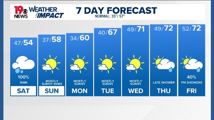
Tomorrow night, the skies are expected to clear up, and the sun should return on Sunday morning. Sunday will feature partly cloudy conditions and dry weather, with high temperatures ranging from the mid to upper 50s.
Week Ahead: A Shift in Weather Patterns
The start of the workweek looks promising with plenty of sunshine through Thursday. However, clouds will begin to roll in on Friday afternoon, bringing a chance of rain showers that could extend into Saturday.
One of the key weather developments for next week is the expected rise in high temperatures. By Wednesday, the region is forecasted to see highs near 70 degrees Fahrenheit. These temperatures in the low 70s are expected to remain in place through Friday of next week and possibly into the following weekend.
The exact temperature trends will depend largely on cloud coverage and whether rain showers occur with the passage of a cold front on Friday night into Saturday. While there is a chance of rain next weekend, it is likely to be confined to Saturday. However, the timing of these events could shift depending on how weather models evolve throughout the workweek.
Summary of Key Weather Trends
- Rain will begin in western South Carolina later tonight and spread across the state on Saturday.
- The Midlands will see rain showers after midnight, continuing through the morning and afternoon.
- Eastern parts of the state and the coast will experience rain until around 6:00 p.m.
- Thunderstorms and heavy rain showers may occur during the rain event.
- Skies will clear tomorrow night, with the sun returning on Sunday.
- Sunday will be partly cloudy and dry, with high temperatures in the mid to upper 50s.
- The upcoming week will start with sunny conditions, but clouds and rain are expected by Friday.
- High temperatures are expected to reach near 70 degrees by Wednesday and remain in the low 70s through the weekend.
- The exact weather patterns will depend on cloud cover and potential rain showers associated with a cold front on Friday night into Saturday.
Posting Komentar