California prepares for flash floods as winter storms arrive
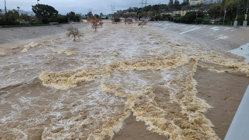
California is bracing for another round of severe winter weather as powerful storms continue to sweep across the state. Following several days of relentless rainfall linked to an atmospheric river, meteorologists are now warning that runoff and already saturated ground could lead to more dangerous conditions. Rivers, creeks, and areas affected by recent wildfires are struggling to handle additional water, prompting emergency officials to shift their focus from total rainfall to the speed at which flooding might occur.
This heightened concern comes in the wake of a deadly holiday week characterized by widespread flooding, numerous rescues, and significant infrastructure damage. In recent days, water has surged through neighborhoods, flooded roads, and left residents trapped in vehicles and homes. These events have changed how authorities assess the next wave of storms, with even moderate rainfall now posing a higher risk, particularly in Southern California and mountain communities near Los Angeles.
The current situation emphasizes the importance of timing and movement as the storm system continues to move eastward and weather patterns remain unpredictable. Forecast models indicate additional rain bands passing through vulnerable regions, keeping flood watches active and emergency crews on high alert. Travel disruptions, evacuations, and emergency responses are expected as conditions continue to evolve. For residents, the experience feels less like a single storm and more like an ongoing test of endurance as winter weather tightens its grip.
Fatal Flooding and Emergency Rescues Across California

Flooding in California turned deadly as days of heavy rain overwhelmed rivers and drainage systems. In Lancaster, authorities discovered a man who died inside a car trapped in mud after runoff swept through the area. This loss followed other storm-related deaths throughout the state during the holiday period. Each incident added urgency as rain continued to fall on already saturated ground.
Further north, a 74-year-old man lost his life in Redding after waters rose rapidly. Around the same time, a Sacramento County sheriff’s deputy died in a single-vehicle crash during wet conditions while driving to work on Christmas Eve. In San Diego, falling debris from storm-damaged trees caused a fatal medical emergency. These events highlighted the varied and widespread dangers posed by the storms.
As conditions worsened, rescue crews worked through the holiday to reach residents trapped by rising water and mud. Air and boat teams pulled people from rooftops and flooded neighborhoods as access roads disappeared. In San Bernardino County, responders reported homes surrounded by feet of mud and water, forcing rapid evacuations. Flood watches remained active as runoff continued to threaten low-lying and fire-scarred areas.
Heavy Snow and Travel Disruptions Spread

Heavy snow spread across the Northeast as the same storm system shifted east and transformed into a different form. New York City and surrounding areas entered winter storm warnings as snow began to accumulate through Friday night. As forecasts updated, emergency officials urged residents to limit travel as conditions worsened. This message followed early snowfall totals that already exceeded initial expectations in parts of the region.
Across Pennsylvania, Connecticut, and Massachusetts, snow continued to build as colder air settled in. In Connecticut, communities like New Fairfield reported multiple inches by late evening. Farther south, parts of Long Island and northern New Jersey saw steady snowfall that reduced visibility and slowed traffic. As roads filled with snow, airports across the region issued weather advisories that quickly affected flight schedules.
Travel disruptions expanded as snowfall intensified around major transportation hubs. Newark, JFK, and LaGuardia posted snow warnings as delays and cancellations climbed through Friday and into Saturday. At the same time, airline tracking data showed thousands of flights were affected nationwide. As the storm pushed north, upstate New York prepared for heavier totals, keeping crews focused on clearing roads and managing overnight conditions.
What Residents and Officials Are Watching Next
Attention remains fixed on weather timing as storm systems continue to move through California. With the ground already saturated, officials are closely monitoring how quickly rain turns into runoff. This focus keeps flood watches active across multiple regions. As forecasts update, emergency teams remain positioned near burn scar zones and low-lying communities.
At the same time, residents are receiving guidance centered on movement and awareness. Local agencies continue urging people to stay alert to changing conditions and road closures. This guidance directly connects to recent rescues and weather-related deaths across the state. As rain bands pass through, small changes in intensity still carry consequences for neighborhoods near creeks and foothills.
Looking ahead, coordination between weather services and local responders remains ongoing. Updates from the National Weather Service shape how crews deploy resources and manage evacuations. This process continues as winter patterns remain unsettled across the West. For communities, daily routines now adjust around forecasts, alerts, and safety updates as storms remain part of the landscape moving forward.
Posting Komentar